Listen
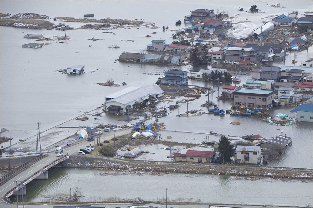
The worst case scenario for flooding from a tsunami along the Pacific Northwest coast just got even worse. Washington's Department of Natural Resources with help from the National Oceanic and Atmospheric Administration re-mapped the maximum tsunami threat from Grays Harbor down to the Columbia River mouth.
Chief Hazard Geologist Corina Forson said updated science about the offshore Cascadia fault zone produced a bigger surge.
"There are places in Ocean City where you have 50 to 60 feet of inundation modeled from this map,” she said. “It is quite shocking. That's on the outer coast if you're standing on the shoreline."
Forson said the biggest difference from previous maps published in 2005 is that the tsunami waves penetrate higher up river and creek valleys. As before, all of Ocean Shores, Washington, most of the Long Beach Peninsula and downtown Aberdeen and Hoquiam could be more than six feet under water.
Forson’s takeaway is that low-lying coastal areas should be thinking about escape methods.
"This is really a tool to push for vertical evacuation structures and informing residents of the hazard where they live," Forson said in an interview Wednesday. "Our next step is working with local emergency managers and planners to update the evacuation routes and educate the community on where the best place to go to evacuate is."
Forson said the earlier and the new tsunami inundation maps both assumed a magnitude 9 earthquake, but the newer modeling produced a bigger movement of the seafloor at the Cascadia subduction zone, yielding a bigger tsunami. The first waves would arrive at the Southwest Washington coast about 15 to 20 minutes after the earthquake.
Forson said her division has a work plan to next publish updated tsunami maps for Bainbridge Island, Whatcom and Snohomish Counties and then the central and northern outer coast.
At a Wednesday meeting convened by Washington Gov. Jay Inslee's office to discuss seismic safety, the superintendent of the Aberdeen School District said tsunami evacuation was under active consideration as the district wrestles with whether to rebuild, relocate or retrofit six old and vulnerable schools.
Dr. Alicia Henderson said an elevated tsunami evacuation platform would get serious consideration if the school at the top of the list for replacement, Stevens Elementary, could not be moved out of the inundation zone.
The neighboring Ocosta School District drew national attention two years ago when it dedicated a new gym at the elementary school in Westport. It has a reinforced roof that can double as a tsunami refuge for 1,000 people, the first of its kind in North America.
Now Oregon State University is preparing to break ground on a new marine studies building next to Yaquina Bay in Newport using a similar vertical evacuation concept. The academic building has been designed with a wide ramp to the roof where more than 900 people could take shelter atop the three-story structure.
Meanwhile, the City of Long Beach on the Southwest Washington coast has put a plan to build a tsunami safe haven on hold. The preliminary design called for a 32-foot tall earth and concrete berm next to Long Beach Elementary School. The flat top of this man-made hill would have offered refuge for townspeople and visitors who otherwise couldn't get to distant high ground in time to escape a tsunami spawned by a major offshore earthquake.
But the latest modeling of wave heights suggests that the proposed elevation is not high enough.
Copyright 2018 Northwest News Network
Related Stories:

Camping At Home? Preparing For ‘The Big One’ Cascadia Quake In The Northwest
When The Big One happens, emergency planners and geologists expect the vast majority of us will survive. But a magnitude 9 rupture on the Cascadia earthquake fault will likely cut electricity, running water and sewer for weeks—or even months afterwards. Continue Reading Camping At Home? Preparing For ‘The Big One’ Cascadia Quake In The Northwest Read More » Tom Banse March 28, 2018
How Will ‘The Big One’ Earthquake Affect Portland And SW Washington? New Study Estimates
No one can say when exactly the next Cascadia megaquake will strike other than there’s a fair chance it’ll happen in our lifetimes. A new study of likely earthquake impacts in the Greater Portland region finds the exact timing and season make a big difference when it comes to casualties and damage. Continue Reading How Will ‘The Big One’ Earthquake Affect Portland And SW Washington? New Study Estimates Read More » Tom Banse March 17, 2018
Cascadia Earthquake Prep: Parents Want Stockpiles At Schools To Prepare For ‘The Big One’
Planned student walkouts this week bring attention to reducing the threat of school shootings. One group of Northwest parents is pushing schools to prepare better for another kind of disaster: a major earthquake. Continue Reading Cascadia Earthquake Prep: Parents Want Stockpiles At Schools To Prepare For ‘The Big One’ Read More » Tom Banse March 13, 2018