Read On
A new online tool by the University of Washington and others maps environmental justice in the state.
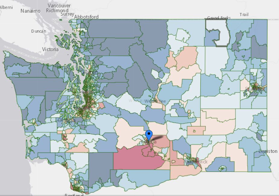
The Environmental Health Disparities Map ranks neighborhoods from 1 to 10. Ten is coded in red, meaning a higher environmental risk while 1, being the lowest, is coded in blue. On that map, Yakima County is a big, red blemish.
It’s one of eight hotspots around the state with concentrated environmental pollution. Other areas include South Seattle/Tacoma, Vancouver and Spokane.
The mapping project is two years in the making, through a collaboration with UW, the Washington State Department of Health, the Washington State Department of Ecology, Puget Sound Clean Air Agency, and a coalition of community organizations called Front and Centered.
The math of the rankings works by looking at the pollution burden and multiplying it by the population demographics. Pollution burden refers to factors like diesel emissions and waste water discharge, among others. Demographics of the area looks at things like low-birth rates, poverty and race.
For Yakima, the biggest concerns are proximity to Superfund sites and hazardous waste facilities, as well as a higher level of homes with lead paint exposure. Pesticides and large animal operations can also negatively impact the air and water quality. Because Yakima County has a greater number of Latino, Native, and low-income populations, all this spells trouble for the health of local residents and where they live relative to polluted areas.
“Our Valley is like a bowl and everything sits at the bottom. And we’re at the bottom,” explains Gracie Partida from Sunnyside.
Partida worked with the Latino Community Fund to connect to rural families who were being impacted by environmental issues. On the road, she heard stories of families who didn’t know how to test their well water, others whose children struggled with asthma.
She adds, “I’m glad the evidence is getting out there, that there’s a map to showcase what’s going on. It didn’t surprise me but I think it needs to surprise other people so they can pay attention to [the inequities].”
In an email, the Yakima Health District says it will be reviewing the mapping tool.