Listen
Emergency meetings are underway to discuss the threat of a possible landslide near Yakima, Washington. Dozens of federal, state, county and tribal officials are trying to work out a plan as this threat looms.
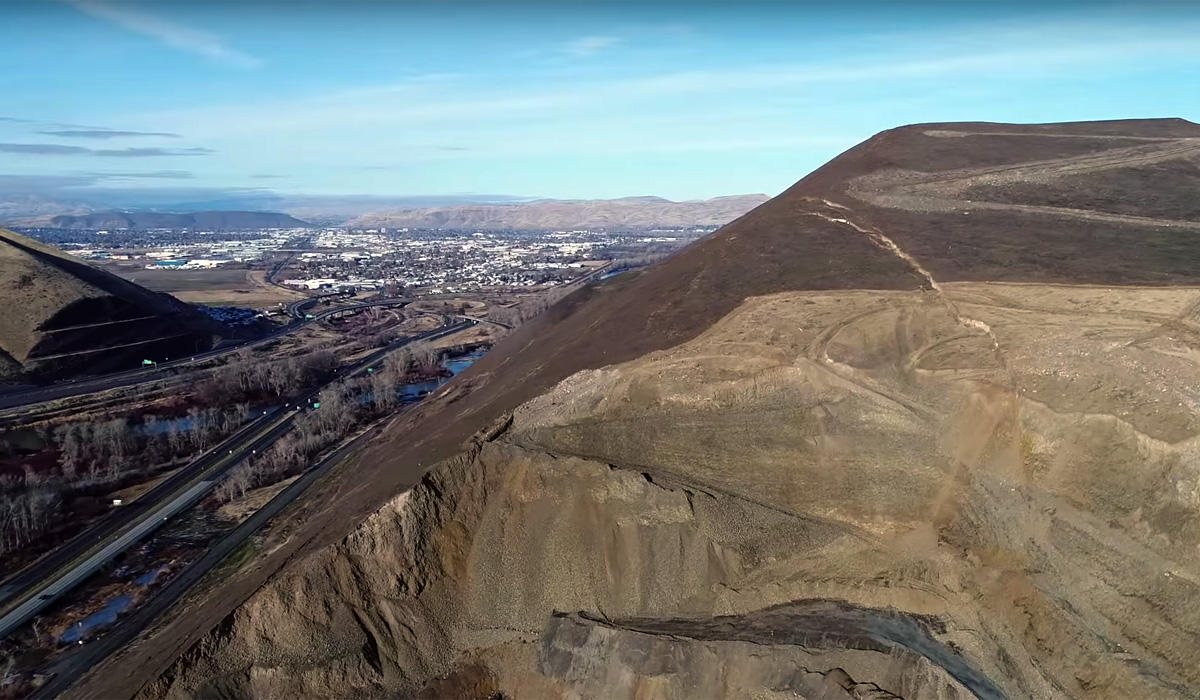
What they’re worried about is that if the big cracks that are now visible on Rattlesnake Ridge give way, debris could flow over Interstate 82 and county roads—and possibly impede, or dam up entirely, the Yakima River.
The river is currently flowing low for winter. So if a slide happens soon, river managers might have ways to stem the flooding.
“The worst case scenario that no one wants to see is if this continues on and carries into the spring,” U.S. Bureau of Reclamation Yakima Field Office Manager Chad Stuart said. “Where the river is traditionally much higher that time of year. And we have a lot more unregulated flows due to melt off and rain.”
Stuart said if the Yakima were totally dammed in spring when flows were high, you could expect flooding into the nearby cities of Union Gap and Yakima.
He also worries about the impact on farmers who need that water in the spring.
“The irrigation season is coming up, and the potential to impact several hundred million dollars of agriculture business and local impact to the economy is just an issue that no one wants to see happen,” Stuart said.
And no one wants to see any damage to two nearby dams on the Yakima either. One dam—Wapato—lies right near the potential slide. The other dam—Sunnyside Diversion Dam—is downstream.
Stuart said if those structures were damaged, it would hamper their ability to control the river’s flows, protect salmon and get water to farmers.
Meanwhile, officials in Washington state are also scrambling to prepare for the possibility of a major landslide. That includes protecting the environment.
At the bottom of Rattlesnake Ridge, Anderson Quarry has been mining for asphalt-making materials for decades. Like any big industrial site, there is a lot of fuel and chemicals on the site.
Officials from the state’s Department of Ecology officials have asked the quarry workers to clean up any toxic chemicals as soon as possible. So far, workers have removed all the fuel oil and propane from the site. But 400 gallons of waste oil still remain.
The weather there is extremely cold and quarry management says the oil is more difficult to get out because it’s partially solidified. The quarry is also trying to keep people safe and says removing it might put people at risk.
The Department of Ecology is working on this because fuel and oils could contaminate the Yakima River—a spot with endangered salmon and threatened bull trout—if a slide did occur.
Copyright 2017 Northwest News Network
Related Stories:

Feds Prep For Yakima River ‘Worst Case Scenario’ At Rattlesnake Ridge
Emergency meetings are underway to discuss the threat of a possible landslide near Yakima. Dozens of federal, state, county and tribal officials are trying to work out a plan as this threat looms. Read More » Anna King January 5, 2018
Residents Weigh Options, Officials Scramble To Prep For Rattlesnake Ridge Landslide
There are about 50 residents in 15 houses and trailer homes on a crescent of land wedged in a depression between Interstate 82 and the hillside that’s cracking near them. According to measurements taken since October by the state and its consultant, the land above this community and Interstate 82 is starting to move more rapidly. Read More » Anna King January 4, 2018
Landslide Threat South Of Yakima Leads To Evacuations Near Rattlesnake Ridge
Officials in Yakima County are strongly urging residents living below a shifting mountainside near Union Gap to evacuate. A huge crack that appeared on Rattlesnake Ridge last year is beginning to widen. Read More » Anna King January 3, 2018