What solutions are Washingtonians considering to manage flooding as the climate changes? - Part One
Listen
(Runtime 1:02)
Read
Jason Vander Kooy said the potential for flooding weighs on his mind every November.
Vander Kooy is a dairy farmer — one of many in northwestern Washington. Two years ago, some farmers there dealt with flooding that killed livestock, damaged fields, and overtopped manure lagoons — meaning the basins that store cow waste filled with water and, like a bathtub too full, spilled over.
“We had one dairy farm, the Nookachamps, where the river rose so fast, he couldn't get his cows out in time and he lost some livestock,” Vander Kooy said.
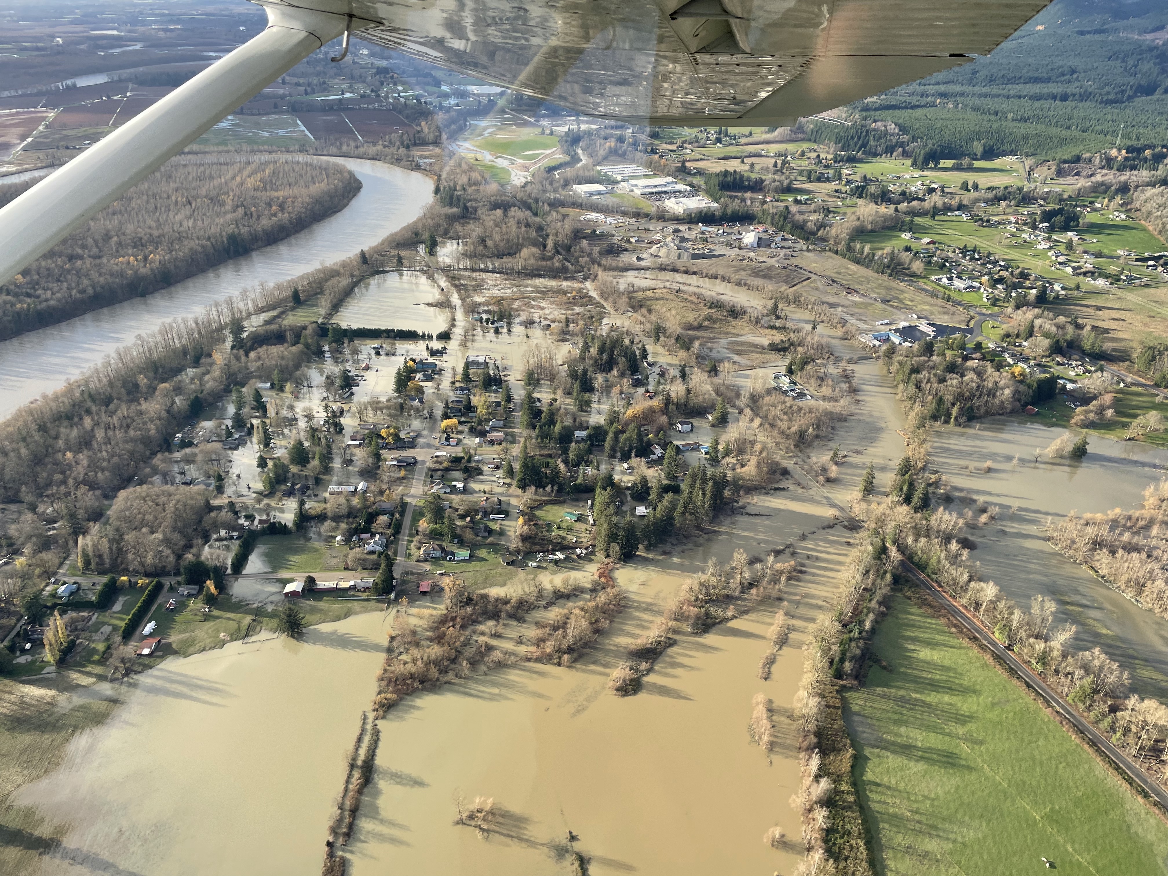
Vander Kooy called the Skagit River unpredictable — with typically only a few days notice before heavy precipitation and potential flooding. The Nooksack and Skagit Rivers run through northwestern Washington, where people have developed communities and agriculture.
Along the rivers there are levees to hold back the water. To keep a levee, or dike, working, maintenance is key, especially after a flood. Vander Kooy is also a commissioner for Skagit County Dike District 1.
“Every year we have a maintenance plan where we keep the dikes in good shape,” Vander Kooy said. “Whether it's vegetation, grass, and noxious weeds, things like that, erosion.”
No levee is foolproof — high waters caused the Nooksack Riverto overtop during 2021 flooding. That flooding impacted approximately 1,200 homes and structures in Whatcom County. A state of emergency was declared in Skagit County at the time and evacuations were recommended as the river crested.
Flooding causes the most damage of all natural disasters in Washington according to the state’s Emergency Management division. As the climate changes, the risk of flooding is increasing in some watersheds. According to the United States Environmental Protection Agency’s Climate Change Indicator on River Flooding, both the magnitude and frequency of flooding are increasing in parts of western Washington.
That means how Washingtonians approach floodplain management is changing, too. That includes changing the systems that hold water back to instead let some water flow more naturally.
How is flooding changing with climate change?
Three factors of climate change contribute to flooding; snow level rise, heavier precipitation and sea level rise.
Guillaume Mauger, a research scientist at the University of Washington, said there is evidence that more precipitation is falling as rain instead of snow, with warming temperatures pushing freezing points to higher altitudes. There is also evidence of sea level rise. Mauger said while scientists aren’t seeing statistically significant examples of heavier rainfall yet, they know it’s coming.
Mauger said dealing with flooding is already a challenge for communities, but stacking climate change on top of that can make it more difficult.
“You're talking about the 100-year flood of today, for example, on the Skagit River, could become a 20-year flood by midcentury or shortly thereafter,” Mauger said. “So, that means it's happening five times more.”
While some inland watersheds have seen more flooding in recent years, some haven’t. That has to do with where the water that feeds into these rivers and streams comes from, explained Nick Bond, the Washington state climatologist. For watersheds mostly fed by snowpack, flooding events haven’t increased, Bond said, whereas ones that get their water from precipitation and snowpack are seeing more flooding.
“With the warmer temperatures that we're having, a greater proportion of the precipitation that falls in the really wet fall and winter months is in the form of rain, rather than snow,” Bond said. “So, it washes off the hill that much faster than it used to.”
Dr. Guo Yu, assistant research professor in hydrological sciences at the Desert Research Institute, explained that with higher temperatures, there could be heavier precipitation. That interaction with the other components of weather, like snowmelt and the watershed itself, can change what happens with flooding.
“It really depends where you are,” Yu said.
Back in the Skagit Valley, repair work was recently completed on five levees along the river.
After devastating flooding in 2021, Vander Kooy said they began to notice erosion and cracking.
“During construction, when they were removing the material, the guy on the excavator, he told me this was going to be a serious problem in that spot, because the ground was so loose, and it was just ready to — it was just moments, another system or two way from a complete failure,” Vander Kooy said.
The repairs to the Skagit River levees should last for up to 100 years.
“By creating these levees and designing them to a certain level of protection, we are saying that we feel confident that a flood of a certain magnitude will be kept within the banks and pass without causing, you know, excessive flooding,” said Krystle Walker, chief of emergency management for the US Army Corps of Engineers.
The Army Corps of Engineers completed the repairs on the Skagit River levees, footing about $5.6 million for the project. The Corps said there is now just a 2% risk of flooding.
“These rivers that they're built on are powerful, and we don't always have the benefit of being able to predict what forces they're going to encounter in a given flood year,” Walker said.
More stories in this series

Part Two: Rethinking levees to reduce flood riskPart Three: The immediate impact of levee setbacks in Pierce County