What solutions are Washingtonians considering to manage flooding as the climate changes? — Part Three
Listen
(Runtime 1:52)
Read
In the foothills of Mt. Rainier runs the Carbon, the Puyallup and the White rivers, meandering through towns and cities, along roadways and near homes, the paint strokes of the natural environment now surrounded by a human-built ecosystem. Once tightly restricted by levees, these rivers are beginning to again flow closer to how they would have naturally, not adhering to the confines and rules of where humans want water to go.
Pierce County is undergoing a number of projects that involve modifying or removing levees, which have been shown to have flood and habitat impacts. To date, the county has completed nine such projects. A 2021 feasibility study evaluated a total of 56 levee setback proposals.
“By setting the levee back, you give the river more access to a broader floodplain, you can lower the velocities in the river during the flood,” said Dennis Dixon, floodplain engineer with Pierce County surface water management. “That can add to the structural integrity — not just its structural integrity, it can diminish the forces that are acting on that levee face during a flood.”
As climate change worsens flooding in some Washington watersheds, municipalities are thinking differently about how the built environment interacts with rivers, to better protect communities, and the ecosystem.
The Puyallup River has experienced some big flood events. Near Orting, eight of the ten highest volume floods in that portion of the river happened in the last 20 years.
The FEMA map for flood risk in Pierce County was last published in 2017, but the data for hydrology and streamflow that informed that mapping came from 1998 and the modeling was done in the early aughts.
Along the river systems, levee setbacks are beginning to have a positive impact.

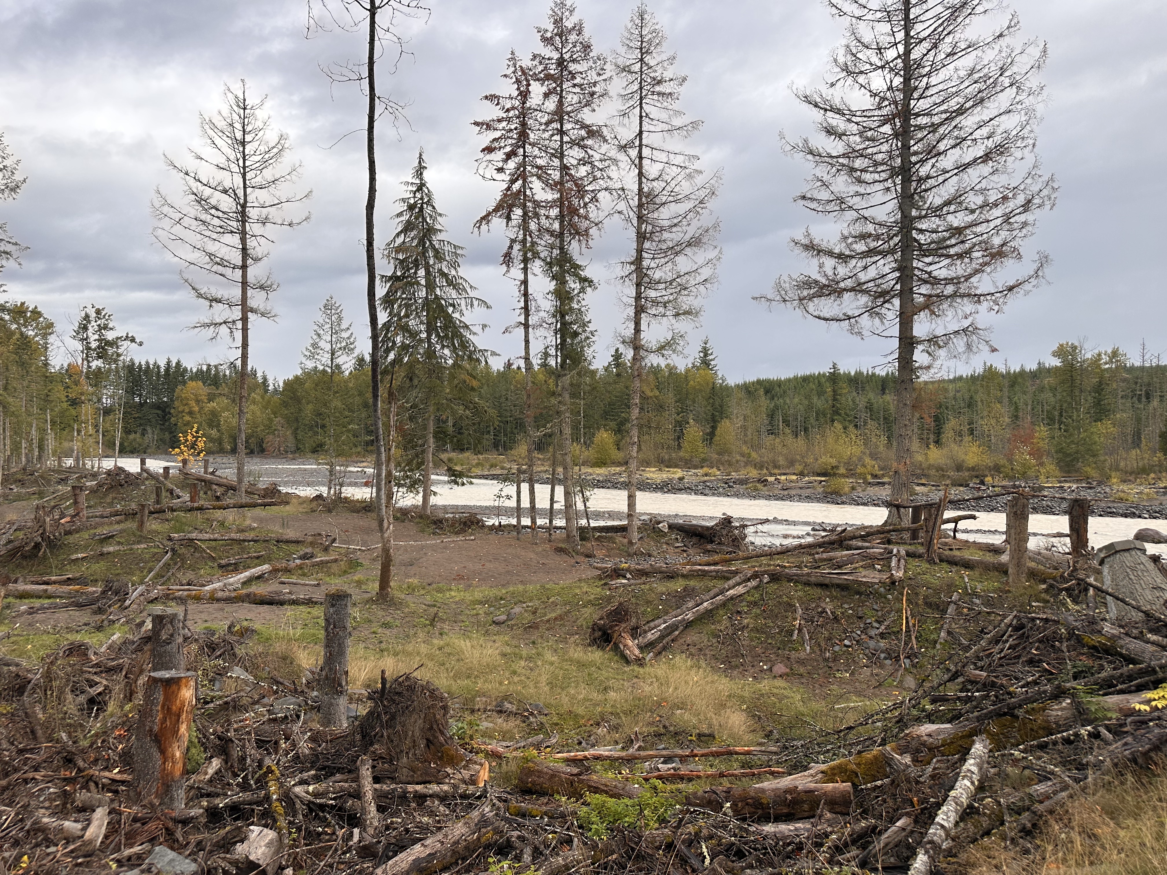
One, the Orville Road Setback Revetment, was completed in 2022. Kathleen Berger, Floodplains for the Future coordinator for Pierce County Planning and Public Works, said the 70-acre project has already been put to use.
“Last year, there was a minor flood event where this project was inundated all the way through,” Berger said. “So the project was activated pretty quickly after its completion.”
The project is adjacent to a primary arterial road, Orville Road, that is used daily and is crucial for emergency access, such as if there were a flood and evacuations were ordered. When rivers butt up right against infrastructure like roads and levees, that creates a lot of wear and tear on the built environment.
“The idea of a project like this is that you're not only creating a natural system, or kickstarting a natural system, for the river to meander, separate, create good habitat for fish and other wildlife, that you're also creating more resilient infrastructure,” Berger said.
The less often the river touches the levee, the less often it will need to be maintained.
This project was completed last summer, after taking 10 years to get to the finish line — and $10 million. Its impact was immediate.
“There's some video footage of when the last of the levee was removed, and it's immediate, the river started to come over this way,” Berger said. “You can see the excavator is pulling the last bit of soil out, and the ground is wet.”
Set back from the river is a meandering, varied landscape where mounds of natural debris pile and slope down to sediment covered rocky beds, with swooping lines that carve through the dirt, carving out what feels like a river bed without water — which in some ways, it is, as the river may rise and flow into this open space.
“Nature is messy,” Berger said. “Nature is supposed to look like this.”

But it takes a lot of engineering to get back to what nature once did on its own.
“There's not enough large, woody debris remaining in the system to create these log jams that you're seeing right here,” Berger said.
In the mounds of woody debris, Berger gestured to concrete dolos, about eight tons of concrete, buried down to the deepest part of the river. Multiple dolos are within each mound of natural debris. They’re anchored together in an effort to prevent the river from undercutting any of the log jams. Dolos are used for a variety of water-dissipating measures, but here they act as a catch to collect these piles to mimic the natural environment.
These projects have a lifespan, between 50 and 100 years, but the county owns this land in perpetuity, so Berger said it will continue to adaptively manage the landscape as it changes.
“The river is going to do what the river’s gonna do too and the river can be powerful enough to adjust things and move them,” Berger said. “It's always adaptive management out here.”

Projects like these are essentially undoing infrastructure that was difficult to maintain, projects built without considering the dynamic nature of rivers and how they can change a landscape, Berger said.
Berger sees examples of that dynamism each time she visits the site.
“I was just out here last Thursday and I don't remember it being up there,” Berger said. “The way that rivers move and change, even over a matter of days, is pretty impressive.”
Editor's note: A previous version of this story misstated the project title as "Orville Road Setback Reinvestment Project." The story has been updated to reflect the actual title, which is the "Orville Road Setback Revetment.
More stories from this series

Part Two: Rethinking levees to reduce flood riskPart One: The increasing risk of flooding